
Wednesday, May 17, 2006
GPS more accurate thanks to the mobile network
Thanks to a GPS antenna and a GPS receiver, we know easily where we are on the Earth (coordinates). Except if we are in a tunnel, in a underground car park or even deep in the city, surrounded by big buildings. The less the signal reception is good, the less the co-ordinates are exacts.
Errors are a few meters but meters in navigation, it's too much.
Too counter that, there are many solutions. The solution of today is the A-GPS , the GPS assisted by the mobile telephony network.
In France, Orange tests it, with the help of Alcatel.
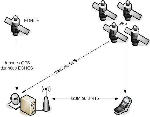
First, the device (a PDA-phone HP iPAQ HW6515) is located via the Orange mobile network. Then, the Alcaltel server, which is linked to the Orange network, sends to the terminal the "assistance data" provided by the european satelite system EGNOS in order to optimize its facility to acquire GPS signals and to allow him to be more quickly and better localised (3-5 m outside, 10 m in extreme conditions).
EGNOS is an europeen system of 3 satellites that already can improve the existing systems : GPS (US) and GLONASS (Russia). Communicating with well-located sites, that kind of system continuously knows the level of reliability of GPS/GLONASS data and transmits it to the users. Accuracy of approximately 5 meters, contrary to the traditional 10 or 20 m.
Let's note WAAS in North America and MSAS in Japan, they have the same purpose than EGNOS.
source : 01net, jeudi passé and Generation NT.
for those which do not know:
A-GPS = Assisted-GPS and
Galiléo =
the future european satellite navigation system (an alternative to the american GPS)
About EGNOS, WAAS or MSAS :
the main attractive point would be downtown, because of the lack of precision, because of a bad GPS reception. Consequently, the EGNOS, WAAS or MSAS signals are poorly received, too ... and that does not work very well.
On the other hand, on the motorway, it works well and the precision is very good. But why would you need a good precision on the motorway ?
Those systems are then mainly used for others purposes, especially the geodesy. Precision is much more important. One point for A-GPS ...
Labels: navigation
archives >> April - March - February - January -December - November - October - September - August - July - June - May
Powered by Stuff-a-Blog
une page au hasard
![]()